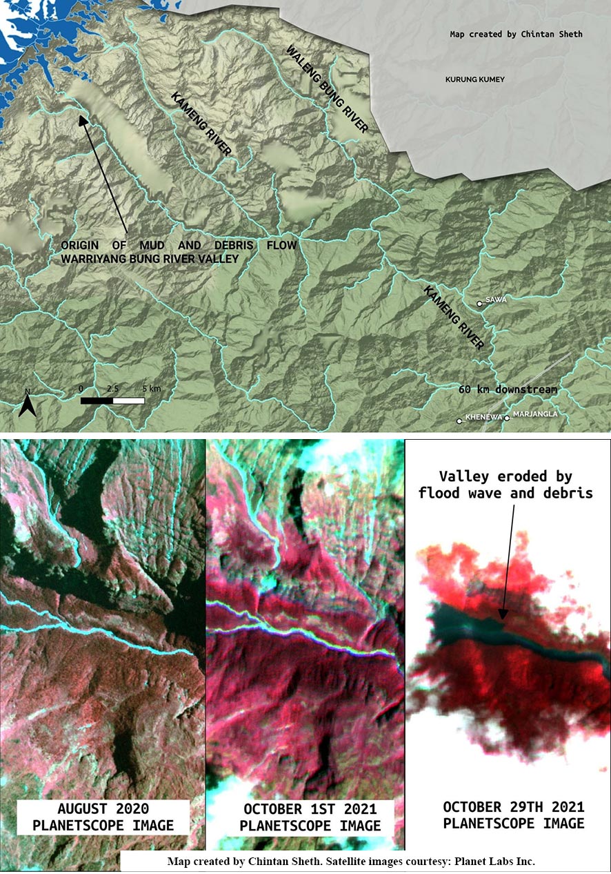
ITANAGAR, 1 Nov: The state government on Monday stated that glacier movement and erosion upstream of the Warriyang Bung river (one of the tributaries of the Kameng river) triggered mudflow, causing the Kameng river to turn turbid.
In a statement, Disaster Management Secretary Dani Salu informed that, according to researcher Chintan Sheth, based on satellite imagery, “the debris flow is visible along the Warriyang Bung river, in Marjangla, Khenewa circle area, and the flood erosion valley is visible.”
“In the upstream of the Warriyang Bung river, there are many glaciers, and it has been observed that the glaciers have moved. However, it remains to be seen whether these glacier movements are normal or abnormal,” Salu stated.
He added that no definite images and information could be gathered by satellites due to heavy cloud coverage over the area.
“Although every effort has been made to find out the exact origin and cause of the disturbance in the Kameng river, no definite images and information could be gathered by the satellites due to heavy cloud coverage in the area,” he stated.
Salu informed that the water level has neither increased nor decreased even after 72 hours, and that the mudflow or debris flow has not abated.
He further informed that the chief secretary took up the matter with Shillong (Meghalaya)-based North Eastern Space Application Centre (NESAC) as well as the Central Water Commission after receiving information from the East Kameng deputy commissioner and asked for their help in identifying the cause and the source of the turbidity.
“The State Remote Sensing Application Centre, Itanagar and NESAC, Shillong have informed that they are in the process of getting clear and more definite images of the area as presently it is under heavy cloud coverage. The ISRO has also been approached to find out the actual cause and place of origin,” he added.
Salu also informed that some independent researchers and professors have approached the East Kameng administration to provide their technical inputs in understanding the root cause of the problem.
The district administration carried out physical inspection of the river at various points along the Seppa-Chayang Tajo road. It was found that the water in all the tributaries, like Para, Pakke, Pachuk, Pachi and Pacha, was clear. In Marjangla, thick deposits of clay and tree debris were found on the banks of the Kameng river.
Earlier, water samples from the river were collected and preliminary analysis was done by the East Kameng DFDO, as per which “the total dissolved substance (TDS) levels were found to be high (6,800 mg/l) while dissolved oxygen (DO) levels were very low (2 mg/l) prima facie, indicating heavy turbidity/mudflow in the river.”
As a precautionary measure, the district administration has imposed 144 CrPC, prohibiting any person from venturing into the river and prohibiting fishing, selling or consuming fishes from the Kameng river for two weeks. Samples of fishes have also been collected and sent for food safety testing.
While no case of diarrhoea or food poisoning has been reported, the government has alerted the health officials to remain vigilant in case of any reported food poisoning or disease outbreak.
“The state government has alerted the NDRF and the SDRF, and the government is closely monitoring the Kameng river’s condition by being in constant touch with the ARSAC, Itanagar, the NESAC, Shillong, the ISRO and the Central Water Commission,” Salu said.
The water turbidity has resulted in the death of tonnes of aquatic lives in the Kameng river, which has caused grave ecological concern among the people and the government.


