

[ Chintan Sheth ]
ITANAGAR, 9 Nov: The Siang river has turned muddy again over the last few days. Two news agencies report that the river is muddy because of construction activities by China in Tibet. However, satellite images reveal that construction activities are not the cause for the muddiness but in fact, a minor landslide has occurred from the Sengdampu valley into the Yarlung Tsangpo river, a few km upstream of Gyala. This valley has several glaciers that feed the river rising up to the mountain peak of Gyala Peri (7294 m). The glaciers in this valley have been receding for several decades and in the last 5 years have been wasting mud, debris and rocks into the river valley.
In October 2017, this very valley wasted mud and debris first muddying the river, after which 15 earthquakes in November 2017 caused landslides across a 100 sq.km leading to extended muddiness into 2018 as well as blockages.
In 2018, extreme rainfall events pushed the Siang/Tsangpo into a historic 50 year flood event that cleared the blockages but also caused flooding and erosion and deposition in East Siang district. In October 2018, the river was blocked twice in quick succession because of mass wasting events (landslide) at this very area where Sengdampu meets the Tsangpo. The blockages cleared into minor outburst floods. A summary of the history of floods on the Siang can be read here.
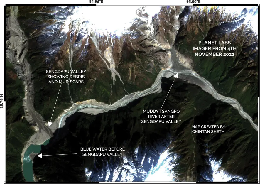
Currently, high resolution satellite images from July until November 8 indicate no ongoing major construction activity along the river. The muddiness starts distinctly near the Sengdapu valley upstream Gyala, and continues all the way into Siang valley even after joining a clear blue Yigong Tsangpo (or Po Tsangpo) river beyond the great bend. Two main areas that have been monitored and analyzed are the region around Gyala and the Yigong Tsangpo-Yarlung Tsangpo confluence. This confluence is about 180 km upstream Gelling and 418 km upstream Pasighat. Sengdampu valley is 237 km upstream Gelling and 475 km upstream Pasighat. No settlements are present between Gyala and the confluence of the Po Tsangpo and Yarlung Tsangpo.
A brief summary interpretation of satellite images from January to November 2022 are as follows: (imagery timelapse can be viewed here https://www.planet.com/stories/sengdapu-valley-january-november-2022-8aaZG0vVg)
For this year, the first mass wasting from Sengdampu valley into the Yarlung Tsangpo can be observed on 1st March.
On 7th March a second mass wasting event occurred larger in extent depositing sediments and mud into the river. There were three 4-4.4 magnitude earthquakes during this time in this area that may have been the triggers for these mass wasting events.
This mass wasting seems to continue all the way into May, showing a muddy Tsangpo after it meets the Sengdampu valley.
In July, too there seems to be mud and debris flowing into the river.
Through August and September some mud and debris are visible and being deposited, muddying the river.
Through October there is some mud and debris flowing into the river however; river seems less muddy further downstream
This change between October and November 4th where a significant volume of mud and debris scars are visible in the Sengdampu valley.
From 4th November to 8th November, the condition of the river seems to be improving with less muddiness and turbidity.
The entire river valley from Gyala to Gelling was carefully scrutinized using imagery from October and November. No construction activities are ongoing that are affecting the muddiness and condition of the river (a view of Siang river at Gelling https://www.planet.com/stories/gelling-november-2022-qfXqGADVg). As of now construction activities are not the cause for the muddiness of the Siang river (a view of the river at Medog town https://www.planet.com/stories/medog-november-2022-hQeCG0DVR).
No blockages or threats to downstream people seem to be present. There have not been any earthquakes in the region since March, however, seismic activity can destabilize rocks and features, and after rainfall or snow these unstable areas can waste mud and debris.
Lastly, the condition of the river is improving, however, due to climate change, extreme heat waves and possible precipitation the Sengdampu valley seems to be continuously wasting debris and mud. This may as well turn out to be the new baseline condition for this river. However, we must not forget what the river was before 2017 and the people of Siang valley may try their best to document the stories and memories from their elders about its condition and aquatic life. The fact that after 2017 the Siang has changed and remained muddy intermittently indicates how perhaps climate change has changed the nature of the river particularly in the winter months.
A robust monitoring system is the need of the hour that continuously measures turbidity, volume and various other chemical and geophysical parameters so as to understand how the river condition is changing and affecting aquatic biodiversity. (Chintan Sheth is a research scientist in ecology, geosciences and conservation and has been working in Arunachal Pradesh for 15 years on the above themes.)


