

[ Chintan Sheth ]
Between 10 and 31 July, 19 earthquakes occurred in Bome county of Nyingchi prefecture in Tibet. Fifteen of these earthquakes occurred within a 300 square kilometre area upstream of the Yigong Tsangpo river (94.743779°E, 30.398025°N).
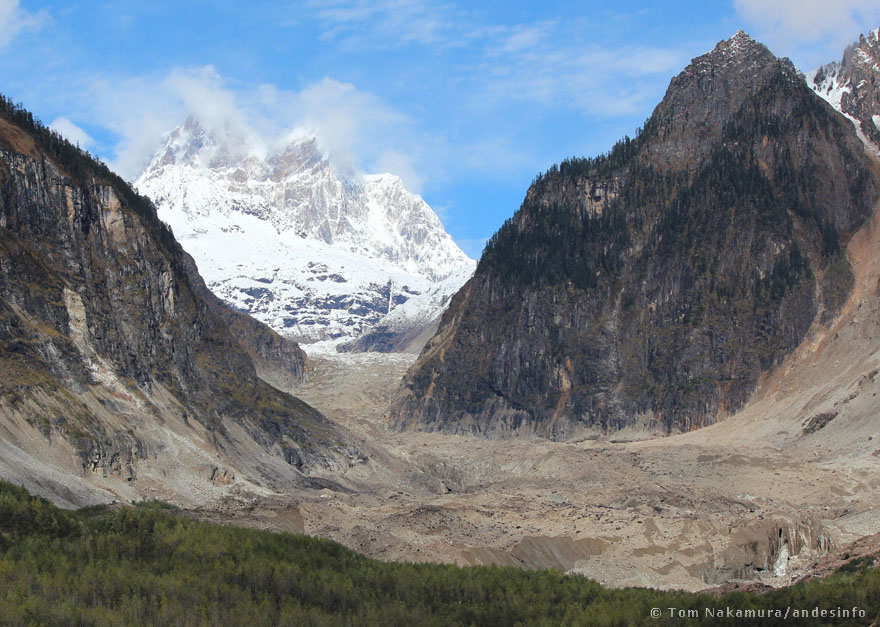
The Yigong-Tsangpo is a major tributary of the Yarlung-Tsangpo or the Siang river. The region where the earthquakes occurred is known as the Nien-Ch’ing-Tang-Ku-La Shan East mountain range (also known as Nyainqentanglha East or Nyanchen Tanglha East). There are more 100 6000+ metre peaks in this mountain range, and as many glaciers and glacial lakes.
The July earthquakes ranged from magnitude 4.0 to 5.0, in a region well-known for earthquake swarms. There have been a reported 11 earthquake swarms in this region that lies at the intersection two major strike-slip faults – the Jiali fault and the Yigong-Lulang fault. This region is a rare seismic region where tectonic swarms occur in the high Himalaya zone. The first recorded swarm occurred in June 1968 and lasted upto September 1968.
The swarm in 2017 (that caused vast landslides and dammed the Siang) occurred south of the current area, with earthquakes occurring for up to a month from November to December 2017, causing landslides and outburst floods in 2018.
Notably, this region of the Nien-Ch’ing-Tang-Ku-La Shan East and the Namcha Barwa massif is known for five outburst floods since 1900.
A history of outburst floods
The first outburst flood occurred after heavy rainfall caused a landslide dam in July 1900. This landslide created the Yigong Tso with a volume of 500 million cubic meters. Local reports recorded by FM Bailey in 1912 indicate that the rock avalanche had heated rocks causing foot blisters. Several people of the Poba tribe migrated to Dibang Valley after this great flood. People from the Adi tribe had also observed several deceased Poba people on the Siang as reported by Bentinck in 1913.
The second outburst flood of the Yigong Tso occurred in July 2000 and is well-known by the Adi tribes of the Siang valley.
This was the biggest outburst flood from a landslide-dammed lake ever documented in modern history. The flood volume of Yigong Tso was estimated to be 2000 million cubic metres. The outburst flood washed out every bridge downstream from YigongTso to Pasighat (a more detailed report of this flood can be read here and here).
The third outburst flood occurred July 2018 after excess rainfall in Tibet led to flooding and clearing of landslide dams on the Yarlung-Tsangpo river. The dams first formed in 2017 after the November-December earthquake swarm mentioned earlier. At least three dams had formed that cleared in July 2018 due to extreme rainfall over a vast area of the Yarlung-Tsangpo river basin. The volume of all three dams was calculated to be 65 million cubic metres. The Central Water Commission (CWC) received data from China indicating the flow rate was 9000 cubic metres per second and was the highest flow rate in 50 years.
The fourth and fifth outburst floods occurred in close succession in October 2018 when a major debris flow event on 17 October from the Sengdam Pu glacier blocked the Yarlung-Tsangpo river. The dam volume was estimated around 600 million cubic metres. China was regularly communicating data with the CWC and the water level recorder in Tuting detected a sharp rise in water level at 11 pm on 19 October, 2018. The flood peaked from 405m to 419m around 12 am on the 20th. By 12 pm on the 20th the flood wave had moved downstream with a water level reading of 407m. At Pasighat the flood wave started at 8 am and peaked at 2 pm on 20 October. At peak flood the wave reached the “warning water level” of 153m.
No lives were lost in 2018. However, multiple rescue operations were conducted by the Indian Air Force and the National Disaster Relief Force in Assam and Arunachal. The outburst floods however did lead to loss of land on a major island part of the Daying Ering Wildlife Sanctuary and led to significant ongoing erosion of the left bank of the Siang along Mebo and Namsing circles of East Siang district.
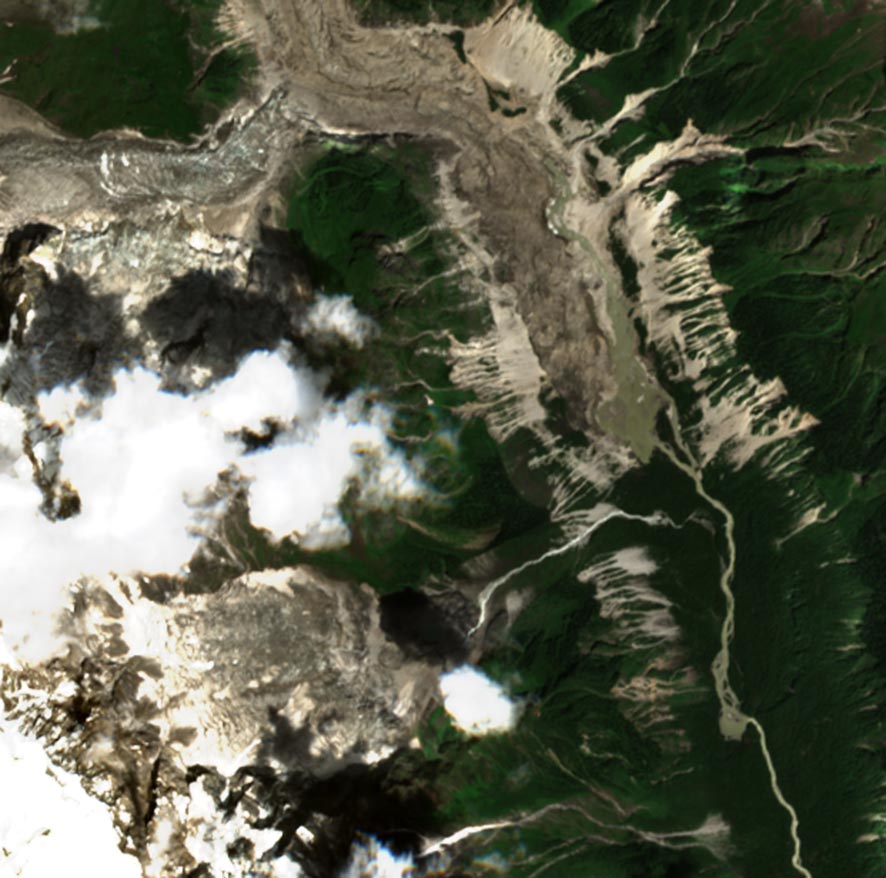
The ongoing earthquake swarms in July 2020 have occurred in extremely remote terrain that takes several days on foot to reach. Of concern is the large landslide dam that was observed on a 27 and 29 July satellite images taken by Sentine-1 and -2 satellites of the European Space Agency. A landslide has occurred from a small glacier in front of the terminus of the Jiangpu glacier (94.547587°E, 30.428263°N, 282 kms upstream of Gelling and 510 kms from Pasighat; pre-landslide image of area from 2011 can be viewed here).
This landslide has created a landslide dam measuring 0.385 square kilometres, blocked by a landslide area of 0.764 square kilometres. Using the area-volume equation published by Fujita in 2013, potential flood volume = dam area (55 x dam area ^0.25), the potential flood volume is estimated at 16.67 million cubic metres. This conservative estimate is based on known area-volume relationships of glacial lakes, and caution must be observed when using this number as elevation data and depth were estimated and not measured.
Nevertheless the potential flood volume remains in the category of ‘potentially catastrophic’ floods and real-time flow data should be requested by India from China.
Need for weather stations and dialogue
Based on the history of this region, we must expect another outburst flood, and several more to come in the years as climate change rapidly accelerates warming and extreme weather in the high mountains of Asia. Once again we are observing the unfolding of complex geological events in one the Earth’s most complex terrain where efficient ground and air operations remain a challenge. The high mountains of Asia are also predicted to have more landslides in the future even if greenhouse gas emissions were to stop.
Given the threats from ongoing climate change and earthquakes in this area, we must accept this risk is part of the river Siang and is not in the control of humans. However, we can prepare and inform ourselves with the best knowledge to prevent the loss of lives, land and revenue. Firstly, river topography is naturally capable of reducing the risk of floods. Ideas of a flood control dam are not founded in good science and engineering. Secondly, with the advances of technology this century, early warning systems can be deployed with ease in Upper Siang and East Siang districts. We can envision a robust early warning system designed to analyze data from automated weather and hydrological stations that measure river flow rates, water level, rainfall, snowfall, stream discharge, etc. The data measured can be analyzed near real-time in what we call a pipeline of data input. The input data can include various other datasets in addition to station data such as earthquakes, land-cover change, flooding, etc.
The resulting algorithm can calculate the risk of flood for a period, thus issuing validated warnings. With ever increasing river erosion in East Siang, where tens of hectares of land have been taken by the river, we must expect the state and the central governments to at least deploy advanced weather and hydrological stations on the Siang as soon as possible to start data calibration at the earliest. The task in parallel should be to expand the data we purchase from China to include hydrological data from the Yigong-Tsangpo river as well. (Chintan Sheth is an independent researcher studying natural hazards, geography and ecology in Arunachal eastern Himalaya. He tweets from @blueczkfox and issues Landslide Nowcasts for Arunachal Pradesh from @ARP_LANDSLIDES.)

