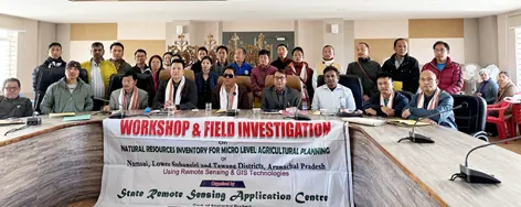
ZIRO, 29 Nov: Arunachal Pradesh State Council for Science & Technology Chairman Bamang Mangha launched a scheme called ‘Natural resources inventory for micro-level agricultural planning (NRIMAP)’ for Lower Subansiri district at the DC’s conference hall here on Tuesday.
He said that the scheme would develop the district, particularly in the agriculture, horticulture and allied sectors, in the coming years.
A brainchild of Deputy Chief Minister Chowna Mein, the task of formulating the project was entrusted to the State Remote Sensing Application Centre (SRSAC), which worked in collaboration with Hyderabad (Telangana)-based Remote Sensing Instruments (RSI).
SRSAC Joint Director Dr Liagi Tajo apprised the officials of the line departments and the district administration of the “meaning of micro-level agricultural planning through resources inventory of the area,” and said that, once completed, the first-of-its-kind project in the state would “tremendously change the agriculture and horticulture scenario.”
He said that “huge databases already created in SRSAC will be kept in repository centre being developed under
Arunachal Pradesh State Spatial Data Infrastructure, which will be widely used by all stakeholders in future.”
The project is being implemented using high-resolution satellite imageries, GIS, GPS and DGPS technology, etc, to utilise natural resources in a scientific way. It will cover the preparation of base map, agriculture and other land use land cover map, hydro-geomorphology map, slope & aspect map, soil resources map, land degradation map, land capability map, and land irrigability map of the study area, according to a release from the SRSAC, which is collaborating with the RSI in executing the project.
RSI CEO BV Ramana Kumar described “the strengths of the RSI in the use of advanced technologies for large-scale resources mapping.” He also explained the importance of base map and thematic maps in the preparation of action plans for the development of land and water resources.
“All this information will be made available on the web application for the administrators and planners to take appropriate decisions for the better usage of natural resources and protect the environment,” he said.
A mobile application will also be developed for use by citizens and farmers to understand the strengths and weaknesses of their land, in order to take appropriate actions for the development of the land to increase its productivity and profitability.
ADC Milo Kojin thanked Mangha, and the SRSAC and the RSI teams for launching the scheme for the benefit of the district.
The meeting was attended by the heads of all line departments.
“Following the meeting, all participants were taken to the soil profile site where soil pit was dug to the size of 1.5 x 1.5 x 1.5 for displaying the vertical section of the soil, showing various layers from the surface to the unaffected parent material,” the release said.
Dr Tajo explained how “various layers, such as Horizons A, B and C, can be seen and how it forms the basis for the study in pedagogical investigations, as it is the key for soil classification and also forms the basis for practical utility of soils.”


