
 [ Chintan Sheth ]
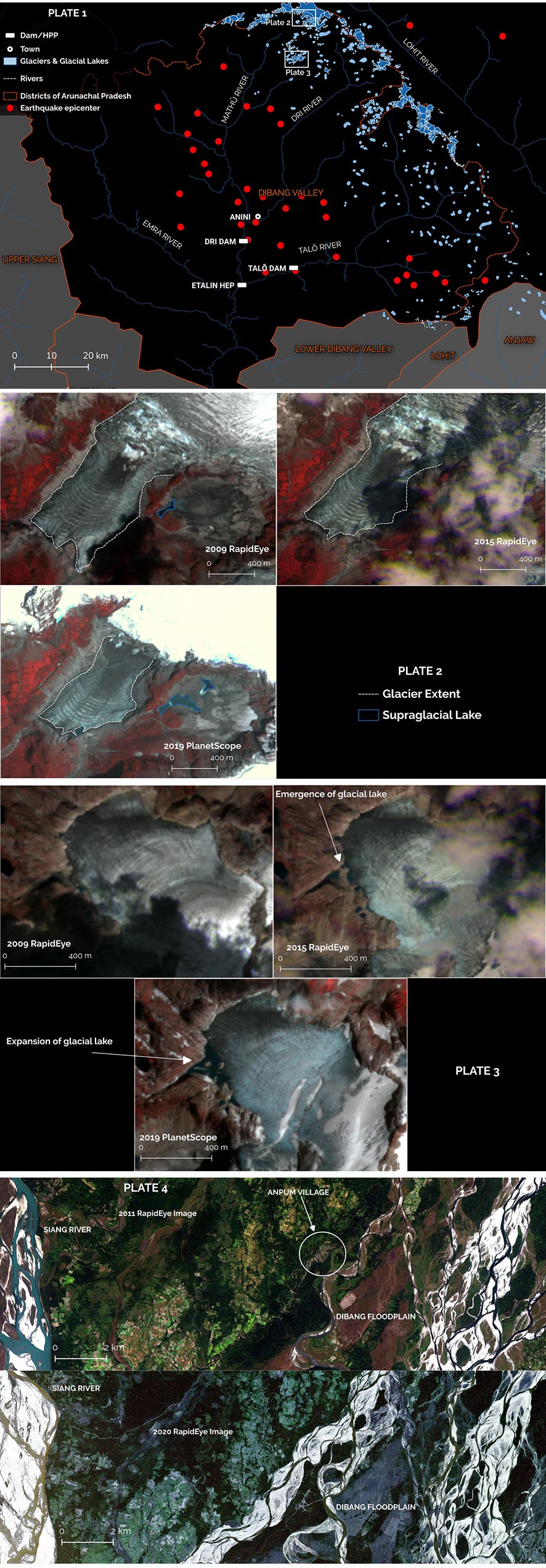
The Mathu (Mathun), Dri and Talo (Tangon) watersheds in Dibang Valley district of Arunachal Pradesh, covering 10,000 km2, are prone to multiple seismic, glacial, landslide and flood hazard risks.
The occurrence of these natural hazards is controlled by complex ecosystems, geological, weather and climatic feedbacks. A combination of anthropogenically induced climate change and seismic activity, exacerbated by the presence of glacial landforms, poses an increased risk of occurrence of natural hazards to this high mountain watershed.
In this article, I present a detailed account of these natural hazards. In particular, I use the example of recent floods to demonstrate the susceptibility of downstream communities to extreme precipitation events. I argue that these natural hazards portend immense risks to communities, ecosystem services, biodiversity, engineering structures and the overall economy of this area.
Till date, these risks have not been comprehensively assessed in the planning of multiple large hydroelectric power projects in the Dibang valley region.
The Mathu (Mathun), Dri and Talo (Tangon) rivers in Dibang Valley are the three main rivers on which two dams are proposed as part of the Etalin hydroelectric power project (HPP). The Etalin HPP is located at the confluence of the Dri and the Talo rivers – 16.5 and 18 kilometres, respectively, from the proposed dams. The HPP is designed to generate 3097 megawatts of electricity. Both dams are located less than 80 kms from the closest glacier.
The three main rivers on which the two dams are proposed originate in the very high elevation regions of the Mishmi mountains, and are fed by melting glaciers, monsoon rainfall and snow-cover melt (plate 1). However, the current knowledge of the region’s hydrology, geology, and potential natural hazards is insufficient to determine the risk it poses to the proposed HPPs.
I present what we know of the natural hazards in the region, based on studies from the high mountains of Asia and my own unpublished data.
Seismic hazards
Since the 1900s, 34 earthquakes have occurred in Dibang Valley district. Within the immediate vicinity of the proposed dams (Talo, and Dri dams), seven earthquakes of magnitude greater than three have been recorded (United States Geological Survey, 2020).
The 15 August, 1950 earthquake, with a magnitude (m) of 8.6, occurred within 70 kms of the confluence of the Talo and the Dri rivers. And in 1951, at least seven (>m5) earthquakes were recorded in the vicinity of Etalin. These seismic events were catastrophic for the region, killing 5000 people, destroying large swathes of land, creating several landslide dams, and outburst floods. These are well documented accounts from the Idu Mishmi community in Dibang Valley and geographers that surveyed the region in the 1950s (Kingdon-Ward, 1955).
The effect of multiple seismic events during that year can still be observed in the mountain slopes of the Talo, Dri and Mathu rivers, and have been studied by Dasgupta, et al (1997). These past landslide areas are devoid of trees, now covered in grassy plains, showing signs of past rock failure, erosion and bedrock exposure.
The next large Himalayan earthquake is predicted to occur in the coming 30 years. After the 2015 Gorkha earthquake (9000 casualties), scientists observed no surface rupture that allows the fault to dissipate its built-up strain (Mencin et al, 2016). They infer that this undissipated strain may add fuel to additional strains developing in the Himalayas.
This is concerning as several historical earthquakes that did not show surface ruptures were succeeded by great earthquakes with ruptures. The most notable example being the m7.3 earthquake in July 1947 in Upper Subansiri district, Arunachal, wherein there was no surface rupture. The additional built-up strain was released 280 kilometres away, in the largest ever instrumentally recorded earthquake in the Himalaya, m8.6 in August 1950, in Lohit district.
Where the built-up strain from the Gorkha earthquake will dissipate is anyone’s guess. There are currently no operational seismic monitoring stations in Dibang Valley. The details above underscore the urgent need for a geological, geomorphological and seismic assessment of the watersheds, with particular focus on the risks they pose to current farmland, community forest land, biodiversity, and HPP and dam structures.
Glacial hazards
Dibang Valley has approximately 300 glaciers upstream of the proposed Etalin HPP, with a cumulative geographical area of 200 km2 (Raup et al, 2007; Global Land Ice Measurements from Space, 2018; Sheth, unpublished data).
Discharge of melt water constitutes the bulk of hydrological stream flow and volume. These glaciers have thinned, retreated and lost mass due to anthropogenically induced climate change (Bolch et al, 2019; Sheth, unpublished data).
Bolch et al, 2019, also provide high confidence for decrease in snow-covered areas and snow volumes in the coming decades. Glaciers in this watershed are expected to lose up to 40 percent of the current volume by 2030, 60 percent by 2050, 80 percent by 2080 and 90 percent by 2100, for moderate warming scenarios.
Glacier ice loss has complex consequences to downstream hydrology, nutrient cycling, ecosystem services and biodiversity. In particular, the reduction in glacier discharge will decrease the electricity production capacity of the forthcoming dams in the coming decades. This is because projected electricity outputs are determined by current flow rates. Along with the reduction in glacier volume it is expected that predictable summer glacial melts will be replaced by far less predictable rainfall events and snow-melt runoffs, making short-term water flow more variable (Milner et al, 2017).
A consequence of glacier thinning is the emergence of supraglacial lakes (lakes on the surface of glaciers) that grow rapidly in size and catastrophically drain as glacial lake outburst floods (GLOF). Geo-hazards such as these are predicted to increase with the ongoing glacier recession as a consequence of historical rather than contemporary carbon emissions, a legacy effect. The Dibang watershed has approximately 350 glacial lakes (proglacial and supraglacial) with a cumulative area of 50 km2 (Sheth, unpublished data). The potential flood volume is unknown, as are the locations of high-volume, high-risk lakes.
Supraglacial lakes and calving of ice have been observed on many of these glaciers, indicating rapid ice loss and risk of outburst floods (plates 2 & 3).
Glacial lake outburst floods cause significant negative impacts to downstream societies due to loss of life, property, ecosystem services, and biodiversity. The devastating impacts of such outburst floods can be best understood through the following excerpt by Schwanghart et al (2016): “In 1985, a proglacial lake of Langmoche glacier, Khumbu Himal, Nepal, emptied rapidly, generating a flood wave with a peak discharge qp of ~2000 m3 s-1, and sluicing 3 x 10⁶ m3 of sediment that obliterated a nearly completed HPP, along with nine years of negotiations, planning, and construction. Torrential rains rapidly raised the water level of the moraine-dammed Chorabari lake, Uttarakhand, India, in June 2013. The dam breached and released 400,000 m3 of water into the already flooded Mandakini river, inundating the pilgrimage city of Kedarnath, and severely damaging at least two HPP sites downstream.”
There is an urgent requirement to map the glacial lakes of this watershed and generate numerical simulations of flood propagation models specific to the topography of the region in order to determine the potential impacts of such floods on downstream communities, fisheries, irrigation systems, and hydroelectric power production. Such an analytical framework is missing from the HPP fact-sheet and environmental management plan.
The proximity of these dams to glacial lakes increases the uncertainty associated with predicting peak discharge during a glacial lake outburst floods, which along with flow rates are the limited yet primary statistics used to design HPPs.
Estimated discharges of glacial lakes can vary by a factor of 100 m3 s-1 for a given lake area. Draining of glacial lakes leads to increased erosion of the bedrock, sediment transport and micro-seismic events, and a deluge that collects rocks and vegetation as the surge propagates. Glacial lake outburst floods have been identified as a major climate change-related threat to hydropower development (government of Uttarakhand, 2014).
It is not certain if the design flood of Etalin HPP has accounted for such variability, nor does the management plan clarify if design flood simulations are appropriate to model glacial lake outburst floods. Dams on river create blockages that allow a flood wave to gather energy once again after the initial outburst flood. This secondary blockage by dams, given the extremely remote and precipitous terrain where these glaciers and lakes are located, is difficult to predict the probability of glacial lake outburst floods using remotely sensed methods.
Additionally, the stability of moraine dams that create glacial lakes is controlled by glacier volume loss and retreat. The stability is also dependent on the frequency of outburst flood triggers, such as earthquakes, avalanches or landslides, into the lake, glacier disruption, and extreme precipitation events.
Extreme precipitation events and floods Dibang Valley district on average receives a total annual rainfall of 4697 mm. The 2015-16 floods in Lower Dibang Valley district obliterated 72 homes in Anpum and Loklung villages, 90 kilometres downstream of Etalin (plate 4).
There is now a river where there were once flourishing villages. These floods were due to extremely high precipitation events in August 2015 and September 2016 (plate 5; Sheth, unpublished data).
Precipitation events, coupled with past alterations in the river geomorphology, perhaps due to excessive sediment load from ongoing landslides at Nizamghat, located a short distance from Roing town, are the likely cause of such dramatic alteration in river morphology. However, glacial lake outburst floods cannot be ruled out, as anomalously high precipitation was recorded across several thousand square kilometres of the Dri, Emra, Mathu and Talo watersheds (Sheth, unpublished data).
Excessive sediment loads typically alter the elevation of riverbeds. The Dibang river has moved westward over the past 30 years, depositing sediments over densely forested landscapes, to merge with the Siang at a location further west, near Gadum. These events are important for two reasons: 1) currently the eastern braids of the Dibang are at a higher elevation with more sediment than the western ones; 2) with ongoing west bank instability, coupled with frequent sinking and flooding, we need to model predicted flow rate, peak discharge and flood propagation if an HPP is installed upstream.
We thus need to prevent the exacerbation of ongoing loss of flat and mountain slopes due to flooding that can otherwise increase arability, conserve elephant corridors and forest land to offset carbon emissions.
Landslide risks
Landslides in mountains often dam, blocking the flow and catastrophically releasing water. The 2018 Siang floods are an example of seismically triggered landslide dams that failed and flooded downstream areas in Arunachal and Assam (Sheth & Roy, 2018).
A recent analysis of the changes in extreme precipitation and landslides in the high mountains of Asia presents a grim outlook of the future. Kirschbaum et al (2020) find that “the rate of increase in landslide activity at the end of the century is expected to be greatest over areas covered by current glaciers and glacial lakes, potentially exacerbating the impacts of cascading hazards on populations downstream. High mountain Asia is home to both monsoonal rains and the largest concentration of glaciers outside the North and South Poles. With climate change, heavy rainfall will increase, especially in mountains near glaciers and glacial lakes. This will make landslides more likely and could present new hazards of landslides releasing a wall of water from glacial lakes, impacting communities and infrastructure located downstream.”
The outstanding questions are:
1. Do the current specifications of the HPP and dam structures allow them to withstand glacial lake outburst floods, seismic events, extreme precipitation events and increased sediment in the face of climate change?
2. Which specific design elements have been incorporated to prevent overtopping of dams due to glacial lake outburst floods?
3. How has the user agency estimated and factored into their proposals the cost of loss of human life and infrastructure that may be incurred due to seismic, glacial lake outburst floods or debris flow events?
4. How has the user agency incorporated into the design of the HPP any additional land submergence that may occur during glacial lake outburst floods or debris flows?
5. How do they plan to provide adequate compensation for such likely future events?
6. Has the user agency deployed automated weather, glacial lake outburst floods and seismic stations across the region to preemptively and comprehensively plan for potentially catastrophic natural hazards?
7. The user agency needs to explain in detail their strategy for sudden release of water to prevent dam failures.
The present locations of HPPs require reconsideration due the aforementioned risks and uncertainties, coupled with a reassessment of the long-term economic feasibility of non-renewable sources of energy.
Plate 5: Plot of precipitation departure from normal for Anpum village in Lower Dibang Valley district. Blue bars indicate precipitation above the long-term mean. Orange bars indicate precipitation below the long-term mean. Shaded regions indicate the standard deviation that may be expected from the long-term variation in precipitation for the area. Long-term precipitation derived from three-hourly estimates of precipitation taken by the Tropical Rainfall Measuring Mission, 3B42 data product, NASA, for the time period 1998 to 2019. (Chintan Sheth is an independent researcher with a BSc in zoology and MSc in geo-informatics.)

