

[ AN Mohammed ]
The Siang river:
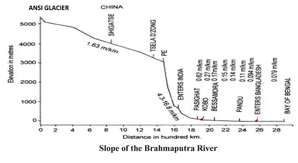
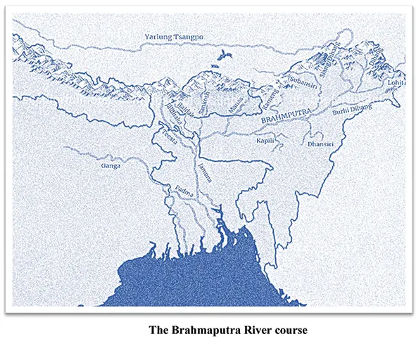
The Brahmaputra river is a 2880 km-long transboun-dary river flows through China, India and Bangladesh. The river originates from the Ansi Glacier at an altitude of 5,300 m about 63 km southwest of Manasarovar Lake close to Mount Kailash in the southwest Tibet and then flows 1,700 km within the Tibet Autonomous Region of China, 920 km through Arunachal Pradesh and Assam, India and 260 km in Bangladesh before it drains into the Bay of Bengal. The river is known as Yarlung-Tsangpo from its origin to Indo-Tibet border. In western Tibet, it flows from west to east parallel to the Himalayan mountains and around the snow-capped massif of Namche Burwa and Gyala Peri and enters into Arunachal Pradesh at Kepang La, near Gelling taking u-turn towards south. It is called Brahmaputra’s Great Bend. Tuting located at an altitude of 1,240 m above mean sea level on the bank of Siang river at a distance of 34 km south of Line of Actual Control (LAC) and 170 km north of Yingkiong situated at 200m altitude.
The catchment area of the Siang river is 2,50,594 sq km up to Pasighat out of which 14,038 sq km lies in India. Most of the catchment area falling in Tibet is affected
by snow and rainfall characteristics are different from Indian areas where river is mainly fed by rain water. The part of Siang basin in India is bounded on the north by eastern Himalayas, on west by Subansiri Basin and on east by Dibang Basin. It flows through Arunachal Pradesh in a more or less southerly direction for a distance of 226 km through steep mountainous gorges before reaching Pasighat having elevation 152 m. Near Pasighat, the river flows in a braided pattern with as many as four channels due to mild slope and silt deposits. River terraces are also noticeable along the river stretches between Yinkiong and Pasighat. From Pasighat, the Siang flows another 52 km before it is joined by two major rivers from east and north-east namely the Lohit and the Dibang, a short distance upstream of Kobo near Sadiya (El 123m) to form the Brahmaputra. The river receives numerous tributaries from both sides all along its course thereby progressively growing in its size. The river is known as Yarlung Tsangpo in Tibet, Siang in Arunachal Pradesh, Brahmaputra in Assam and Jamuna in Bangladesh. The Brahmaputra with average annual flow of 615 billion cubic meter is one of the largest rivers in the world by annual yield and its tributaries provide significant ecological, cultural, and economic services to millions of people residing in Tibet (China), North-eastern India and Bangladesh. Siang river contributes 25-33% of water to mighty Brahmaputra.
Water availability:
The average annual rain fall in the Indian catchment is about 3,251 mm while the maximum and minimum temperatures are 40° C and 5° C respectively. The maximum rainfall is experienced during the month of June to September with occasional rainfall in May and October. Heavy pre-monsoon rains are also experienced in February and March. Siang river after entering Arunachal Pradesh travelled about 204 km to meet Siyom, a major tributary which contributes 30% to the discharge of Siang at Pangin. The average monsoon and nonmonsoon peak discharges at Pangin are 3,170 and 1,132 cum/sec. Before reaching confluence with Siyom a few streams also join the river Siang contributing about 20% discharge. The flow entering Arunachal Pradesh can be assumed 50% of the discharge at Pangin. It implies that maximum and minimum average discharges entering Arunachal Pradesh is about 1,600 and 550 cum/sec respectively. Average annual discharge of Siang river is 120 billion cum @3800 cum/sec recorded at Pasighat.
The International Centre for Integrated Mountain Development (ICIMOD) and other two international organizations in its research paper titled ‘The Himalayan Climate and Water Atlas: Impact of Climate Change on Water Resources in Five of Asia’s Major River Basins’, analyzed climate changing now and into the future, ‘with severe consequences for populations, both local and downstream of five major river basins – the Indus, Brahmaputra, Ganges, Salween and Mekong. Due to global warming, temperatures across Tibetan plateau will increase by about 1-2°C (in some places by up to 4-5°C) by 2050. Rainfall pattern will change with the monsoon expected to become longer and more erratic and violent. Glaciers will suffer substantial ice loss. Despite overall greater river flow projected, higher variability in river flows and more water in pre-monsoon months are expected, which will lead to a higher incidence of unexpected floods and droughts greatly impacting on the livelihood security and agriculture of river-dependent people.’
Historic floods in the Siang river:
Himalayan floods are produced by breaches of landslide and glacially dammed lakes. Glacial lake outburst floods (GLOF) are caused by the breaching or overflow of a lake formed due to damming by a glacier and landslide lake outburst floods (LLOF) are formed by landslides. Many scientific researches revealed that Brahmaputra valley had been thrashed by several mega floods. In Tibet, during the Neogene period (1.7 million to 11,700 years ago) several lakes were formed by dams created by the deposition of rocks and debris carried by glaciers. The volumes of the lakes were as high as 800 million cubic meters (Mcum). The outbursts of these lakes generated mega floods in the Brahmaputra valley. Testing of flood deposits (silt etc) in the Brahmaputra valley indicate that they were originated mostly in Tibet and the floods evacuated huge volumes of sediment from the Tsangpo Gorge. Test data on fine grained sandy sequences found at 90m above river bed level at Panging and Pasighat in Arunachal Pradesh indicate that at least one of these mega floods occurred between 8,000 and 6,000 years ago, another such event occurred 1,200-1,650 years ago, 18 mega floods of varying sizes occurred between 27,000-18,000 years ago and two mega floods between 27,000-10,000 years ago. The climate record from Mawmluh Cave, Meghalaya indicates a relatively warm and wet phase during which the mega floods occurred. Present global warming and climate change phenomenon may make the environment conducive for some more mega floods in the Brahmaputra valley in the near future.
Among the recent mega floods, a 60-meter high and 2.5-km wide dam was formed in Tibet by a major landslide that occurred on 9th April 2000. The dam breach caused floods that wreaked havoc in Arunachal Pradesh on 11th June 2000, claiming 30 lives and leaving more than 100 missing. Water level rose to 40 m at Tuting. Most of the bridges were washed away and roads were damaged and more than 50,000 people in Arunachal Pradesh were left homeless by the floods. The extreme flood slowly lost its forte due to spreading in the plain areas before entering Assam in Sadiya.
The water colour of the Brahmaputra turned blackish due to high turbidity during November-December 2017. Dead fishes were seen floating at Pasighat due to contamination of the Siang river. Water of the tributaries, eg, Dibang, Lohit, Subansiri were clear which confirmed the root of pollution in Brahmaputra was Siang river only. At this time discharge of Brahmaputra was normally 6,000 cum/sec at Pandu and average water entering India at Tuting is 1,000 cum/sec which confirm high contamination in Siang river. A scientist from the National Centre for Biological Sciences, Bengaluru, using satellite imagery from NASA, USA reported that between 21- 27 October 2017, an avalanche releasing water, ice, rocks and other debris occurred on the Sendapu glacier which feeds into the Yarlung-Tsangpo river. Pools of water could be seen on the glacier surface, indicating that melting ice may have caused mud and rocks to slip. This was the first indication of the Siang river being contaminated by natural reasons in early part of November 2017. Complicating further, a M6.4 earthquake struck on 17 November 2017 triggered widespread landslides on the Yarlung-Tsangpo river at 200 km upstream from Tuting. A satellite image five hours later showed several landslides and a 100 square-kilometre area of mountain slope entirely collapsed. Three natural rockslide dams formed on the river due to blockage by landslides and debris. It is only a matter of time before the natural dams burst and unleash a severe disaster along the Siang and Brahmaputra valley. However fortunately, the artificial dams instead of sudden break, slowly breached draining the water of the artificial lakes averting major disaster downstream in Arunachal Pradesh and Assam. Such incidences of abnormal flow variation and contamination of water observed in the Siang river from time to time. (The writer is a hydropower expert with 40 years experience in NE India.)


