

[ AN Mohammed ]
China’s secretive plans:
Since the 1990s, there has been speculation about China’s plans to build a megadam on the Tsangpo river at the Great Bend, capable of generating 38 gwof electricity and diverting water through a 1,000-kilometre tunnel to the arid northern regions. China initially dismissed these plans as economically unviable due to the remote location. However, in 2020, Beijing officially announced its intention to build the dam, raising alarms in India over potential impacts on water and food security. The project could severely affect livelihoods, ecology and water availability for millions downstream.
India fears that China might weaponise water by calculatedly causing floods during monsoons or droughts in non-monsoon periods. India has repeatedly urged China to ensure transparency and engage in consultations to safeguard downstream interests.
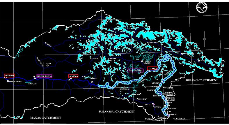
China asserts that its hydropower projects planned on the Yarlung Tsangpo are run-of-the-river, minimising downstream impacts, but India remains sceptical. Despite the absence of a water-sharing treaty, India and China have agreements in 2005, 2008, renewed in 2013 and 2018 for sharing hydrometeorological data and providing flood warnings during monsoon months. Under these agreements, China shares hydrological information (water level, discharge, rainfall) from three Tibetan stations – Nugesha, Yangcun and Nuxia – between 15 May and 15 October each year. The two countries have also coordinated on emergency responses for landslide-induced blockages downstream of Nuxia, as seen in October 2018 when China reported such an event and shared hourly observations. However, cooperation has been inconsistent, with data-sharing disruptions during periods of tension, such as the 2017 Doklam and 2020 Ladakh standoffs.
China’s super dam:
In December 2024, China’s state news agency Xinhua announced the approval of a massive hydropower project on the Yarlung Tsangpo in Tibet, which could generate three times the energy of the 22.5 gw Three Gorges Dam. This mega project, with an estimated cost exceeding US$137 billion, faces unprecedented engineering challenges. The Yarlung Tsangpo, Tibet’s longest river, flows through the world’s deepest canyon and features a 2,000-metre vertical drop over 50 kms before entering India, offering nearly 70 gwof hydropower potential. The project involves drilling four to six 20 km-long tunnels through the Namcha Barwa mountain to divert half of the river’s flow, around 2,000 cumecs (cubic metres per second). Once completed, the 60 gw hydropower station is expected to produce over 300 billion kWh of electricity annually.
Xinhua emphasised that extensive geological exploration and technological advancements have laid a solid foundation for the project’s safe and high-quality development. The project prioritises environmental protection and aligns with China’s green energy transition, carbon peaking, and carbon neutrality goals, as well as global climate change mitigation efforts. However, the project raises significant concerns for downstream regions, particularly India, regarding water availability, ecological impact, and potential geopolitical implications.
Journey of the Siang:
The Siang river starts from the Ansi Glacier at an altitude of 5,300 metres, about 63 kilometres southwest of Manasarovar Lake near Mount Kailash in southwest Tibet. It flows for 1,700 kilometres in Tibet, where it is known as the Yarlung Zangbo or Tsangpo, and then flows for 278 kilometres in Arunachal Pradesh. In western Tibet, it travels from west to east, parallel to the Himalayan mountains, and passes around the snow-capped peaks of Namche Burwa and Gyala Peri, carving through the world’s largest canyon, the Yarlung Tsangpo Grand Canyon, which is 240 kilometres long, with an average depth of 5,000 metres.
The river enters Arunachal as the Siang at Kepang La near Gelling, taking a U-turn towards the south around the Brahmaputra’s Great Bend at an elevation of 535 metres near Tuting, and 170 kilometres north of Yingkiong, situated at an altitude of 200 metres. In Arunachal, the Siang river flows southward for 226 kilometres through steep gorges before reaching Pasighat at an elevation of 152 metres, where the river flows in a braided pattern with several channels due to the mild slope and silt deposits. River terraces are noticeable along the stretches between Yingkiong and Pasighat. From Pasighat, the Siang flows another 52 kilometres before joining two major rivers, the Lohit and the Dibang, near Sadiya in Assam at an elevation of 123 metres, forming the Brahmaputra. The Brahmaputra then flows for 642 kilometres in Assam and 260 kilometres in Bangladesh, where it is known as the Jamuna, before draining into the Bay of Bengal.
River discharge and flows:
Wide variances in precipitation and snow melts have resulted in huge variations in the flow regimes across the Tsangpo basin. The average annual discharge and flow of the Tsangpo is 91 bcm (billion cubic metre)and 2,900 cumecs, respectively. The average annual discharge and flow of the Siang river is 120 bcm and 3,800 cumecs recorded at Pasighat. The average annual discharge and flow of the Brahmaputra is 615 bcm and 20,000 cumecs. The overall snowmelt contribution to annual runoff in the Tsangpo catchments is about 34 percent, with 10-25 percent during monsoon and 5-10 percent in winter months.The annual precipitation in the Trans-Himalaya averages about 300 mm. As the flow moves to the south of the Himalaya, the annual average precipitation reaches about 4,500 mm. The foothills are frequently fed by inconsistent precipitation of magnitude that can cause great floods. The peak flows at Nuxia in Tibet, the nearest station to the Great Bend is about 6,000 cumecs, while lean season flow is calculated at 500 cumecs by Chinese researchers. An important left-bank tributary, Parlung Tsangpo joins the Yarlung Tsangpo further 130 kmsdownstream of Nuxia. The precipitation increases substantially downstream of their confluence. This substantially increases the flow downstream of Nuxia. The discharge of the Yarlung Tsangpo increases by more than twice as the river crosses Nuxia, undertakes the Great Bend, and enters India.
India is most concerned of the area between Nuxia, the last hydrological station from which India receives flood-period data, and Tuting, the first hydrological station within Indian territory between which the river traverses approximately 320 kms. On this rain-rich part of the journey of the river, however, no data is available. The regions exhibit high monsoonal precipitation with strong possibilities of landslides and avalanches that could lead to flashflood events. This is corroborated by the fact that in many of the patches, 10 or more instances of such hazardous events occur yearly, increasing the hazard risk further downstream. The downstream districts of Arunachal and Assam are most vulnerable to floods. The Yarlung Tsangpo Great Canyon has 17 snow-clad peaks above 6,000 metres. Historic floods and droughts frequently thrash the Siang river due to creation of artificial dams by landslide and glacially dammed lakes blocking the river flow for a long time and subsequent breaches releasing huge quantity of water.
From the available hydrological data during 2008,including from Tuting (1978-1992, 1995) and Yingkiong (1977-1991), it was seen that the minimum flow of the Siang at Pasighat in non-monsoon period was of the order of 1,000 cumecs. There was no consistent data to ascertain what would be the corresponding minimum flow of the river in China, where the proposed megadam would be located. Keeping in view the fact that river reaches in China region are largely snow fed, minimum discharge would be sufficiently lower than that available at Pasighat, 226 kms away from China border. As several streams and large tributaries like the Siyom joins the Siang in Indian catchments, the minimum flow in China territory was considered half of that at Pasighat, maximum diversion that could be theoretically affected by China would be of the order of 500 cumecs (power potential studies of Lower Siang HEP approved by CWC). With this quantity of water, a 60 gw project is possible because of utilisation of 2 km head available at the Great Bend of the Brahmaputra as power generation in a hydroelectric plant is directly proportional to the quantity of water and head (height of water flow to the power plant).
China planned to produce 300 billion kilowatt-hours (kWh) of energy annually from 60 gw plant, utilising 2,000 cumecs flow with 2,000 m head. In comparison India’s Lower Siang HEP near Pasighat designed to produce 13.93 billion kilowatt-hours (kWh) from 2.7 gw plant, utilising 5440 cumecs flow from 55 m head.
Impacts of Chinese megadam:
The extent of implications from proposed project depends on China’s planning for conventional hydropower or for multipurpose consumptive use for irrigation, drinking water and diversion of Tsangpo water to its arid northern areas. If the project is utilised solely for hydroelectric power generation as indicated by China, once the reservoir is filled up, the power plant can be continuously run if the river flow is more than 2,000 cumecs (designed discharge of the power plant) during monsoon period and downstream areas will get normal river flow. There will also be probability of dam induced flood. If stored water in the reservoir is released suddenly, the downstream areas will be flooded. By virtue of its location at the foothills of the Himalaya and the abrupt decline in the river’s gradient, Siang valley districts especially become a potentially vulnerable zone. This can also seriously affect the neighbouring districts of Sadiya, Tinsukia and Dibrugarh in Assam with the travel time of flood wave from the Great Bend to Dibrugarh being about 12 hours.
During non-monsoon period, the flow of the Tsangpo goes below 2,000 cumecs. The power plant will have to be frequently stopped for hours or even days for replenishment of reservoir, during which there may be no flow in the downstream as China may not release minimum environment flow like Indian hydropower dams mandatorily release. In such a situation, there will be drought-like situation in the downstream and the most affected area will be the 150 km reach from the Indo-China border to the Siyom river confluence at Panging where the Siang river may dry up.
Conclusion:
The Siang river, the lifeline for the Adi tribe of Arunachal, supports the culture and livelihoods through fishing, and agriculture has repeatedly suffered from many historic floods, droughts, and polluted water threatening the ecology of the region. The available hydrometeorological data shows that the Siang contributes 25 to 33 percent water to the Brahmaputra, whereas the Yarlung Tsangpo contributes about 7 to 15 percent. It is inferred that China may have been using a substantial quantity of Tsangpo waters during non-monsoon periods for irrigations, drinking, etc. China’s announcement of construction of 60 gw Yarlung Tsangpo mega dam at the Great Bend raises pressing concerns about environmental impacts, mostly on the Siang river. Without a formal water treaty between China and India, the protections offered by international laws on trans-boundary rivers may be insufficient to address the complexities of such a mega project. As such, transparency and international cooperation are paramount importance to ensure a balance between the project’s benefits and its potential risks.
Constructing large reservoirs on the Siang to store potential floodwaters released by China and releasing during droughts stands out as the most viable solution to secure optimal water availability in the Siang/Brahmaputra, safeguarding the interests and wellbeing of all affected regions. As China has already started activities for construction of the mega project as revealed by satellite imageries, India must take up counter actions on priority to save the Siang river from imminent risks. (The contributor is consultant, hydropower development in NE India.)


