

[ AN Mohammed ]
China’s Great Bend mega-dam: Scale, secrecy and downstream risk
For over three decades, China’s ambition to harness the immense hydropower potential of the Yarlung Tsangpo river at its dramatic Great Bend in Tibet remained a subject of speculation. The project was once dismissed by Beijing itself as too difficult and uneconomical because of the region’s extreme terrain, deep gorges and remoteness. That perception has now changed decisively.
In December 2024, China officially approved a 60 gw mega hydropower project, nearly three times the capacity of the world’s largest Three Gorges Dam. Located barely 30 kilometres upstream of Arunachal Pradesh, the project involves diverting nearly 2,000 cubic metres per second (cumec) of water through a network of long tunnels bored deep into the Namcha Barwa mountain range. With an estimated cost of over USD 137 billion, the project is expected to generate more than 300 billion units of electricity annually. Public reporting also notes that a formal construction start ceremony took place in July 2025, even as many design details remain unclear in open sources.
China describes the project as ‘runoftheriver’and environmentally benign. However, the sheer scale of tunnelling, diversion and storage makes this claim difficult to accept. For downstream India -particularly Arunachal and Assam – the dam raises serious concerns about water security, flood safety, ecological balance and longterm geopolitical vulnerability.
Control over the headwaters gives China the ability to regulate river flows at will. This opens the possibility of artificial floods during the monsoon or reduced water availability during the dry season. In the absence of a legally binding watersharing treaty between the two countries, downstream regions remain exposed to unilateral upstream decisions.
Fragile cooperation, growing uncertainty
India and China do have limited agreements -signed in 2005 and 2008 and renewed later – for sharing hydrological data during the monsoon season. Yet, cooperation has often been inconsistent. Data sharing was disrupted during the Doklam standoff in 2017 and again after the Ladakh crisis in 2020, highlighting the risks of relying solely on goodwill rather than enforceable arrangements.
A major concern is a 320kilometre stretch between China’s last monitoring station in Nuxia and India’s first station in Tuting, where no realtime data is available. This stretch passes through one of the world’s most landslide and avalancheprone regions. The absence of information from this ‘blind zone’ significantly increases flood risks for downstream communities in the Siang and the Brahmaputra valleys.
The river system is naturally volatile and the ‘blind zone’ raises the hazard.
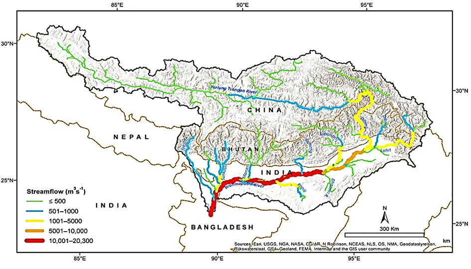
Significant changes in precipitation and snowmelt have caused variable flow regimes in the Tsangpo basin. The river has an average annual discharge of 91 BCM and a flow rate of 2,900 cumecs. Over its 1,700 km course in Tibet, average streamflow varies from under 500 cumecs in the upper reaches to 1,000-5,000 cumecs near Arunachal. At Pasighat, the Siang river averages 120 BCM annually at 3,800 cumecs, while the Brahmaputra in Assam and Bangladesh averages 615 BCM and 20,000 cumecs. Snowmelt makes up about 34 percent of runoff in the Tsangpo catchment, with annual rainfall ranging from 300 mm in the trans-Himalayan area to 4,500 mm south of the Himalayas. Irregular rainfall often causes flooding, especially in the foothills.
In Nuxia in Tibet, flows peak at 6,000 cumecs and drop to 500 cumecs during lean periods. Downstream, after merging with the Parlung Tsangpo, both precipitation and river volume increase. As the Yarlung Tsangpo enters India past the Great Bend, the discharge more than doubles. The 320 km stretch between Nuxia and Tuting, though rain-heavy, lacks hydrological data and faces high landslide and avalanche risks that can prompt flashfloods. Arunachal and Assam are particularly flood-prone. The Yarlung Tsangpo Grand Canyon, which is 240 kilometers long with an average depth of 5,000 metres, features 17 peaks above 6,000 metres, and both artificial and natural dams frequently cause major floods when breached.
History warns: Natural dams fail catastrophically
Himalayan floods are largely caused by breaches in lakes dammed by landslides or glaciers. Glacial lake outburst floods (GLOFs) and landslide lake outburst floods (LLOFs) have led to significant flooding events, particularly in the Siang and the Brahmaputra valleys, with notable incidents traced back from the Neogene period (23 to 2.6 billion years ago) through recent history. Flood deposits and their origins in Tibet, discovered at higher elevations in Arunachal, indicate that massive floods have occurred at different intervals over thousands of years, often during periods of warm and wet climate.
Recent events include a significant breach of a landslide-dammed lake in Tibet that occurred on 9 April, 2000, causing extensive flooding and devastation in Arunachal. The incident resulted in numerous casualties and rendered more than 50,000 individuals homeless. In late 2017, river contamination occurred due to an avalanche on the Sendapu glacier and a subsequent earthquake on 17 November that triggered landslides and the formation of natural rockslide dams. While these dams raised the risk of catastrophic floods, gradual breaches prevented major disasters downstream.
The Siang and the Brahmaputra valleys continue to experience abnormal flow variations and periodic pollution, with global warming potentially increasing future risks.
Climate change: A dangerous multiplier
Climate change is now intensifying these risks. The Tibetan plateau and the eastern Himalaya are warming faster than the global average. Glaciers are retreating, snowfall is declining, and rainfall is becoming more erratic. In the short term, this means higher flood peaks during monsoon months. In the long term, it threatens reduced dryseason flows, increasing the likelihood of droughtlike conditions downstream.
When such climatedriven volatility interacts with a massive upstream reservoir, the risks multiply. Sudden releases or prolonged withholding of water can exacerbate both floods and water shortages. Climate change, therefore, acts as a force multiplier, magnifying the strategic and environmental implications of China’s mega dam.
China’s massive dam: Potential risks for downstream areas
Even assuming that the Chinese project is operated primarily for hydropower, two classes of risk remain:
First, flood risk-from sudden releases, cascading operational decisions, or dam safety challenges in a seismically active, landslide-prone region.
Reporting on the project emphasises that key details- especially storage capacity and operational procedures – are not publicly transparent, which is precisely what downstream planners need for credible risk modelling.
Second, dry-season vulnerability, when flows fall below the levels needed for continuous power generation, withholding and pulsed releases become more likely. Without binding environmental-flow obligations enforceable across borders, downstream stretches could face sharp variability, affecting drinking water, agriculture, fisheries and riverine ecology.
India’s sole strategic buffer: Upper Siang dam
Recognising this altered reality, India has proposed the Siang Upper Multipurpose Project (SUMP) as a large storage-based intervention. India’s ministry of external affairs, in a public parliamentary response, explicitly lists the 11,200 mw SUMP with 300 m high dam and 9.2 BCM reservoir as proposed safeguard on the Siang in Arunachal.
In strategic terms, the case for a storage reservoir is not only electricity. It is buffering capacity: absorbing sudden upstream surges, storing water for lean months, stabilising flows, reducing disaster exposure for Arunachal and Assam, and strengthening India’s bargaining position by reducing dependence on upstream discretion.
It is, in effect, a national safety instrument in an era where hydrology and geopolitics increasingly overlap.
The Adi and the Siang: From resistance to responsible safeguards
The concerns of the project-affected Adi community, whose cultural, spiritual, and economic connection to Ane Siang is fundamental, are of primary importance. It is essential that a project of this magnitude gives due consideration to the affected communities and ensures that consultation processes are meaningful and substantive rather than procedural formalities.
Yet the larger risk is strategic helplessness. An upstream mega project controlled by a state with which India has unresolved border tensions poses a long-horizon hazard that local communities will bear first. The choice, therefore, is not between ‘river’ and ‘dam’, but between unmanaged vulnerability and managed resilience.
The constructive path forward is conditional engagement: insisting on the strongest possible environmental safeguards, transparent risk studies, credible seismic design standards, fair rehabilitation, cultural protection, and institutionalised participation- so that river security and civilisational continuity are pursued together, not traded off.
Conclusion: Defending the river’s future
River dynamics have repeatedly disrupted complex societies, destroying villages and urban centres, causing dispersal, and occasionally altering entire civilizations. Historical and archaeological evidence indicates that floods, river shifts, siltation, and water-system failures significantly contributed to the decline of major riverbank societies. Among many instances, explanations for the Harappan/Indus collapse often cite sudden environmental events like flooding and river drying or rerouting, along with climate stress and social changes.
Impacts of climate change and China’s mega dam have fundamentally altered the hydropolitical reality of the Tsangpo-Siang-Brahmaputra basin. In the absence of a binding international treaty, India’s best defence lies in proactive infrastructure, not reactive diplomacy.
The Upper Siang project does not entail compromising identity or ecological integrity; rather, it focuses on ensuring the security of the river, its people, and their collective future. A proactive approach for the Adi community would involve conditional engagement – advocating robust safeguards, equitable rehabilitation, cultural preservation, and inclusive participation. Through such measures, the Adi people actively protect Ane Siang’s legacy, recognising that inaction is no longer a neutral option in contemporary times. (AN Mohammed is a consultant on hydropower development in Northeast India)
